MARINE SPATIAL PLANNING TOOL
MSP TOOL
WebGIS Platform for tidal in-stream current energy development
Hydrodynamic Modelling
Engr. Oliver Dan de Luna, Engr. Justine Ace S. Santos
Delft3D Flow software was utilized to simulate the tidal behavior of Philippine seas for the country’s assessment of tidal current energy resource. Hydrodynamic modelling of the major regions of Luzon, Palawan and Mindanao seas were conducted and the results were validated against observed data from 45 IHO tidal stations (International Hydrography Organization). The simulation period was 1 year with data recorded every 60 minutes. Input parameters to the model were bathymetry (NAMRIA), sea-bed friction coefficient and the boundary conditions. Tidal harmonic constituents for the boundaries were obtained from a global inverse tidal model (TPXO 7.2). In comparing the model results and data from the tidal stations, the coefficient of determination R2 was used as a measure of goodness-of-fit. With a few exceptions, The R2 were at least 0.85 indicating high agreement between predicted and observed data.
Hydrodynamic Modelling using Delft3D
Site-Device Matching
Engr. Michael Bausas
After potential sites have been identified, performance analysis of various tidal in-stream energy conversion technologies (TISEC) was done. A working list of 22 TISEC devices was adopted for analysis. The list was based from a shortlisting made by the International Renewable Energy Agency (IRENA) in 2014, wherein active TISEC device developers were identified using different criteria – project development; technology classification; evidence of a modelling program; and full-scale.
A comprehensive survey on the technical/operational, as well as economic characteristics of these pre-identified TISEC devices was carried out to develop a TISEC devices database. The performance analysis of the devices at a given tidal site (based from site resource and suitability analysis) was based on three main factors, namely: annual energy yield, capacity factor and availability factor. It was originally intended to include the economic characteristics of the devices in the analysis, for the purpose of cost comparison, but was later shelved due to the unavailability of the necessary data.
A sample rotor of a tidal turbine
Site-Suitability Analysis
Joselito Cruz, Engr. Patrick Jay Y. Lucañas
In coordination with the Department of Science and Technology, UP College of Geodetic Engineering, the Training Center for Applied Geodesy and Photogrammetry,and Marine Science Institute, was contracted to develop a tool for local governments that would assist in the developing a renewable tidal current energy integrated resource assessment and spatial planning tool. In particular, the agencies wanted to develop a potential site suitability for some renewable resources. This was accomplished by gathering available data sets and developing geographic information system (GIS) data layers that can be used to determine the suitability of a shoreline for tidal current energy development. Using landscape and seascape areas, and bathymetric data, this GIS modeling effort results in a mapping scheme showing color-coded segments, point-polygon and rasters data for the gathered data came from other local government agencies for renewable resource site suitability assessment.
This also need for implementing the Analytic Hierarchy Process (AHP). AHP helps the decision-makers to choose the best solution from several options and selection criteria. It is also used as a decision-making method for broading the applications in operations research and quality engineering. This will model AHP that can generate output that includes measures weights of criteria and selection importance and data consistency.
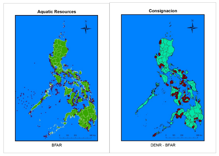
Sample data from the Bureau of Fisheries and Aquatic Resources (BFAR)
Environmental Impact Assessment
Justine Jose dela Cruz
Ocean Renewable Energy systems are emerging energy conversion technologies which capitalize on the perpetual motion of ocean currents due to gravitational and tidal forcing. The archipelagic configuration of the Philippines with its numerous inter-island channels and embayments translate to a relatively high ORE resource potential. Examples of prevalent ORE systems include wave, ocean thermal and tidal in-stream energy conversion devices. Tidal current velocity is perceived to have the highest potential for the Philippines. The Philippines is also considered to have one of the most biodiverse marine ecosystems in the world. Environmental impacts of technological development endeavors such as TISEC deployment must be minimized if not become negligible to maintain biodiversity and ecosystem integrity.
Target biota include coral reefs, reef fish, plankton, and pelagics, to name a few. Initial findings show that EU/NA assessments have minimal focus on tropical reef biota while looking more towards large marine invertebrates and pelagics. Assessment methods such as fish visual census and reef transect provide insight for baselining and monitoring in Philippine seascapes.
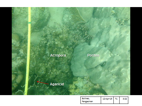
Image of coral reef transect survey with coral ID
Image of coral reef transect survey with identified and algal turf
WebGIS Development
Engr. Luis Caezar Ian Panganiban, Engr. Charmyne Mamador
PhilSHORE tool is a web-based GIS (geographic information system) application which allows stakeholders, such as the government, academe and private institutions concerned with ocean renewable energy, to readily assess the potential and suitability of a particular location for ocean energy developments. This service provides data access to different site-suitability layers and device information. Also, it includes a raster calculation function, which can implement a weighted overlay analysis using the different site-suitability factors to create their own energy assessment map. The data available on the map were resource, site suitability and device layers.
The resource layers contains power and velocity which was modelled using Delft3D and regional IHO tide stations. Device performance such as Availability and Capacity Factor and Potential Power, were derived from aforementioned resource layers. PhilSHORE tool was developed using different open-sourced libraries and frameworks like Leaflet JS, D3 JS, GDAL, NumPy, Django and others. Django a python web framework was used as the primary structure for building the application. Geospatial Data Abstraction Library and NumPy were used for manipulating different suitability and device layers. Leaflet JS (http://leafletjs.com/), the primary mapping library used to create the map interface and overlay the different site and device layers. Data Driven Documents JS was used for visualizing site and device data through creating different graphs and charts. The PhilSHORE tool, with its capability to provide initial assessment for determining sites for ocean renewables, is a contribution in the development of Ocean Renewable Energy in the Philippines.
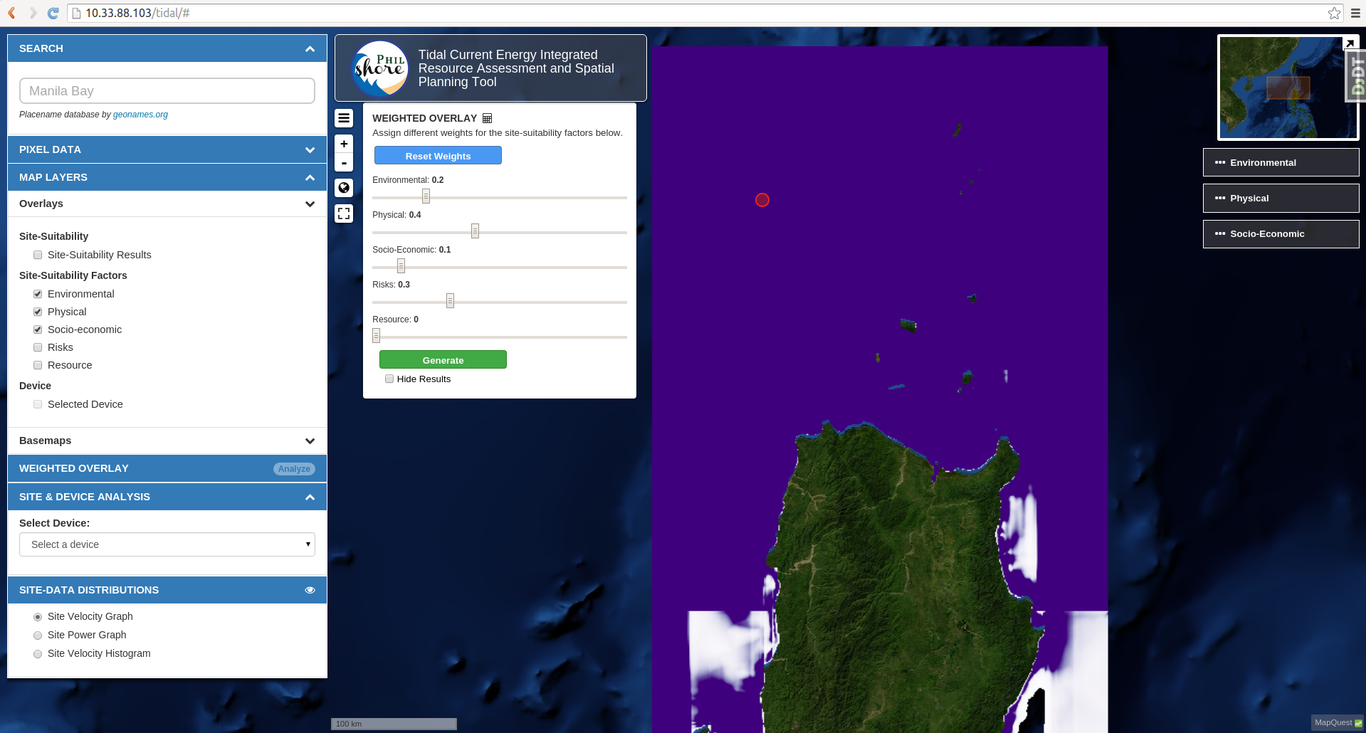
Screenshot of the PhilSHORE tools' Raster Calculator Feature